Dunons as defendable cities
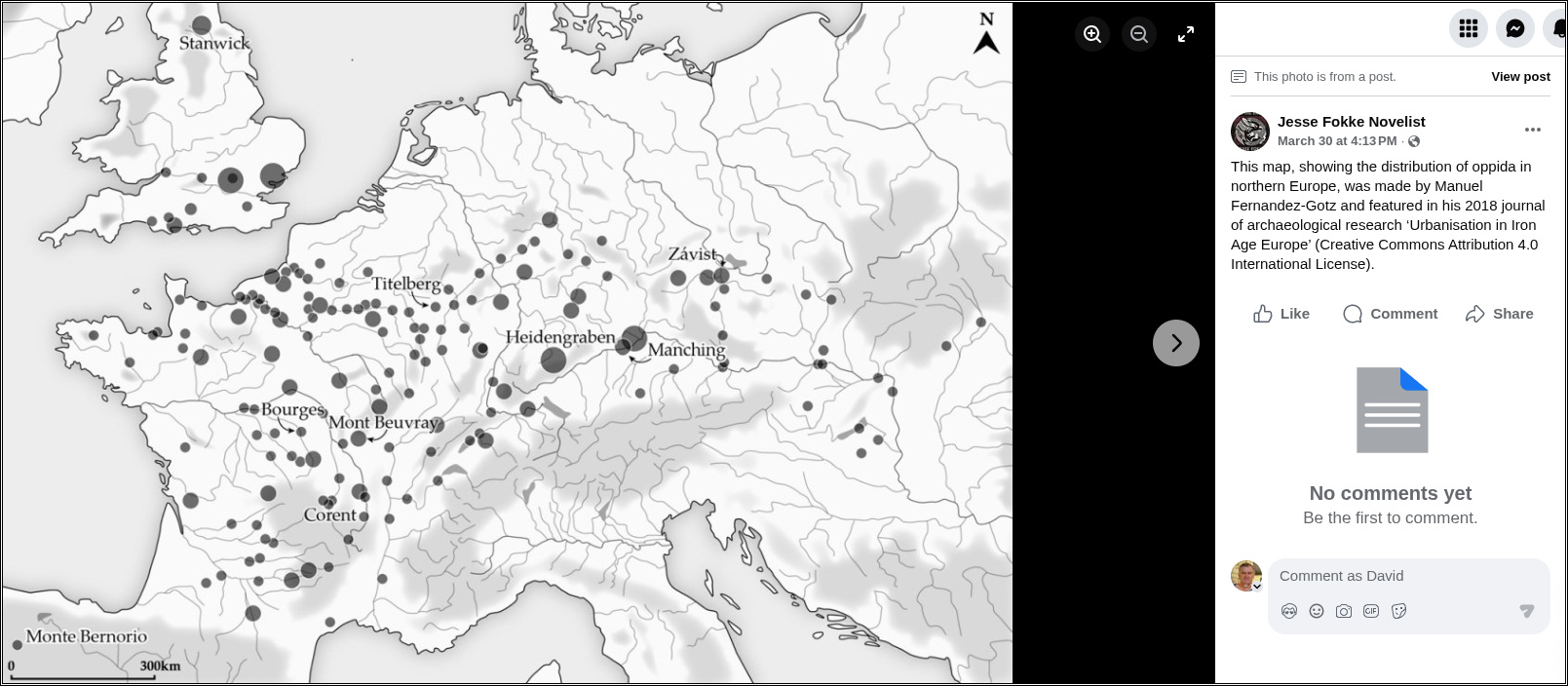
Jesse Fokke Novelist The oppiduma (Gaulish: dunon) was a type of settlement found in many parts of Celtic Iron Age Europe, including Great Britain, the Low Countries, France, Spain, Germany, Switzerland and the Czech Republic. They were often situated in well-defensible sites, such as hilltops or within river bends, and were enclosed by thick stone walls, with a timber skeleton. Some of these oppida were quite small, and were little more than shelters in times of war, while others were very large and fairly densely populated. Here are a number of oppida, in ascending order of surface area (in hectares), including the associated tribe (if known) and location:
0.12 ha - Verduron (Salluvii, Marseille, France) 2 ha - Malpas (Segovellauni, Ardche, France) 3.5 ha - Entremont (Salluvii, Provence, France) 3.5 ha - Mnsterhgel (Rauraci, Basel, Switzerland) 4 ha - Mont-Terri (Rauraci, Basel, Switzerland) 7 ha - Roquelaure-la-Sioutat (Ausci, Gers, France) 7 ha - Marduel (Volcae Arecomici, Gard, France) 8.5 ha - Glauberg (Unknown tribe, Hessen, Germany) 9 ha - Numantia (Arevaci, Soria, Spain) 10 ha - Lindenhof (Helvetii, Zurich, Switzerland) 12 ha - Nages (Volcae Arecomici, Gard, France) 12 ha - Moulay (Cenomani?, Mayenne, France) 15 ha - Sos (Sotiates, Landes, France) 15 ha - Ensérune (Volcae Arecomici, Occitanie, France) 19 ha - Maiden Castle (Durotriges, Dorset, United Kingdom) 22 ha - Ãauze-Esberous (Elusates, Gers, France) 26 ha - Avaricum (Bituriges, Berry, France) 27 ha - Argentomagos (Bituriges, Berry, France) 28 ha - Gondole (Arverni, Auvergne, France) 30 ha - Les Césarines (Cadurci, Dordogne, France) 30 ha - Jensberg (Helvetii, Bern, Switzerland) 32 ha - Calleva Atrebatum (Atrebates, Silchester, United Kingdom) 35 ha - Milseburg (Unknown tribe, Hessen, Germany) 37.5 ha - Star Hradisko (Volcae, Moravia, Czech Republic) 40 ha - Devilâs Dyke (Catuvellauni, Hertfordshire, United Kingdom) 40 ha - Pommiers (Suessiones, Aisne, France) 49 ha - Menosgada (Boii?, Bayern, Germany) 50 ha - Chateliers (Turones, Indre-et-Loire, France) 50 ha - Le Titelberg (Treveri, Luxembourg) 50 ha - Uetliberg (Helvetii, Zurich, Switzerland) 50 ha - Eburodunon (Helvetii, Yverdon-les-Bains, Switzerland) 50 ha - Boviolles (Leuci, Meuse, France) 50 ha Corent (Arverni, Auvergne, France) 60 ha - Lactora (Lactorates, Gers, France) 70 ha - Andematunnon (Lingones, Haute-Marne, France) 70 ha - Gergovia (Arverni, Auvergne, France) 70 ha - Martberg (Treveri, Mosel, Germany) 80 ha - Rheinau (Helvetii, Zurich, Switzerland) 80 ha - Uxellodunon (Cardurci, Lot, France) 80 ha - Murcens (Cadurci, Lot, France) 90 ha - Stradonice (Boii, Bohemia, Czech Republic) 90 ha - Dansberg (Ubii, Gieen, Germany 100 ha - Villeneuve-Saint-Germain (Suessiones, Aisne, France) 120 ha - Vesontio (Sequani, Franche-Comt, France) 140 ha - Bibracte (Aedui, Bourgogne, France) 140 ha - Alesia (Mandubii, Bourgogne, France) 140 ha - Brenoduron (Helvetii, Bern, Switzerland) 150 ha - Zsvist (Boii, Bohemia, Czech Republic) 167 ha - Castellier (Lexovii, Normandie, France) 170 ha - Fosss des Pandours (Mediomatrici, Alsace, France) 200 ha - Altenburg (Helvetii, Baden-Warttemberg, Germany) 240 ha - Donnersberg (Nemetes?, Pfalz, Germany) 380 ha - Manching (Vindelici, Bayern, Germany) 500 ha - Durocorteron (Remi, Reims, France) 600 ha - Kelheim (Vindelici?, Bayern, Germany) 1,700 ha - Heidengraben (Unknown tribe, Swabian Jura, Germany) +2,600 ha - Camulodunon (Trinovantes, Colchester, United-Kingdom) Image 1: This map, showing the distribution of oppida in northern Europe, was made by Manuel Fernandez-Gotz and featured in his 2018 journal of archaeological research â Urbanisation in Iron Age Europeâ (Creative Commons Attribution 4.0 International License). Image 2: Artist's rendering of an oppidum by Kenny Arne Lang Antonsen (CC BY-SA 4.0).